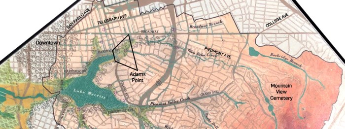
What’s the deal with (specifically this corner of) Adams Point?
 The (first?) 2020 COVID lockdown is likely the closest many of us have come to experiencing the stoppage of time. But the virus reminds of how quickly things can imperceptibly evolve. Maybe it’s against our nature to notice – humans seem to prefer stasis – but change occurs constantly at every scale of our lives, from the microscopic to the built environments we’re lucky to call home.
- Adams[‘] Point
- Power & Water
- The Triangle
- Conservatory
- Valdez
Take a look at Adams Point, a 280-odd-acre neighborhood by Lake Merritt in Oakland. It’s a particularly curious example of perpetual development spanning 80 years.
On Park View Terrace, 1956 & 1909
On a recent lockdown walk into the Point, I finally noticed an astonishing intermingling of architectural styles – not just a couple instances, but throughout the entire neighborhood. A kneejerk “what happened here??” reaction soon became a quest to understand Adams Point’s history, and maybe find an accessible way to express it. What resulted was a “hyperlocal postcard” focusing on the neighborhood’s most prominent intersection, and a heap of research that informed it:

 “Twenty-fourth and Harrison,” (*) the onetime frontier of Oakland, now marks the edge of downtown. This intersection has always played host to city and regional landmarks – ever of the “finest construction.” A cable car powerhouse (turned automobile showroom turned supermarket) once moved commuters to Piedmont and coexisted with an iconic baths building (1). By 1905, a city founder’s (/squatter’s??) estate would be annexed and split into a lakeshore park and a highland subdivision (2). The divider, Grand Avenue (3), guided a streetcar line to Pleasant Valley (now Grand Lake). A triangle of marsh-land where Glen Echo (once Cemetery) Creek met Lake Merritt was gradually tamed into a focal point of the lake’s 1910s-1920s beautification, with a Veterans Memorial building overlooking a necklace of lights along the shore (4). A relocated Episcopal church grew to become a residential and educational campus, establishing one of the first lakeside midrises (5). In fact, in nearly every decade of the twentieth century new housing was introduced to Adams Point, creating a rich architectural and cultural fabric; the tradition carries on today in the conversion of former parking lots and garages a few blocks west (6). Of course a global pandemic will dramatically change aspects of life, but it could hardly dent the momentum of Oakland extending to more neighbors its bounty.
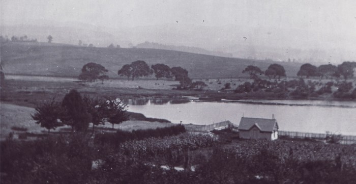
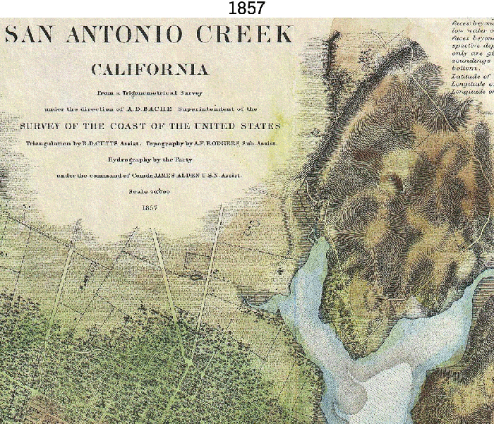
The exact place of study was once and often known as the “head of the west arm of Lake Merritt.” Certainly the Chochenyo Ohlone had a different name for this place, as did the Peraltas who assumed the property in the 1820s-1840s under the Mexican flag, and again at the time of Oakland’s 1850s founding when Lake Merritt had no name, and was still an estuary.
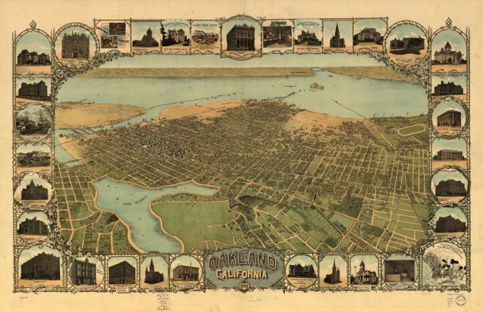
Fred Soderberg Oakland, California, 1900 color lithograph, via LOC
If the above is an aerial representation of Oakland circa 1900 – when the Town was riding a 50-year wave of progress starting with the gold rush, statehood, and city incorporation, followed by the 1869 arrival of the transcontinental railroad but before the 1906 earthquake and influx of refugees – then the postcard examines this part:

By the 1910s (shown above), housing construction was on a steady post-earthquake surge. As the postcard mentions, the heirs of Oakland cofounder Edson Adams had at last ceded his bucolic lakeside estate. Development kicked off in earnest. Above you can see Montecito Avenue climbing into a thicket of bungalows. The “triangle of marsh-land” is now a park that Adams had poured funds, earth, and topsoil into beautifying, to sell to the City to become the first public land fronting Lake Merritt.
The rest, as they say, is a .gif:
From another angle, consider the west arm’s watershed. Glen Echo Creek’s headwaters are predominately in Mountain View Cemetery (hence its original name). Parts of this waterway are still daylit, either coursing through narrow, contemplative parks, between back yards, or between holding ponds in the cemetery. Down by Lake Merritt, as seen from a cutout along the Vets building, creek water levels will fluctuate with the tides.
Watershed map via interpretive sign at Lake Merritt

2. Power & Water
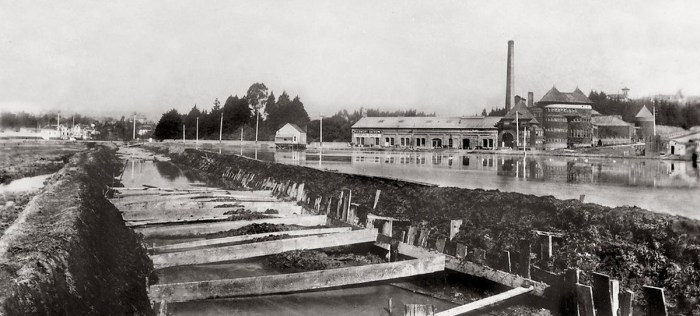
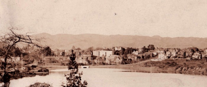
This image may be of Adams’ channelization of Cemetery (Glen Echo) Creek in the 1890s. The scene is scrutinized by a strange architectural symbiosis. The cable car power house (center) took in lake water and generated steam that was utilized by the iconic Piedmont Bath House (right). The baths in turn attracted day trippers to use the cable car. The baths burned down in 1927. Before then however, cable cars were replaced by electrified streetcars. The power house was revitalized twice, once as a Cadillac showroom, and most recently, of course, as a Whole Foods – uses apace with the interiorizing of this part of town.

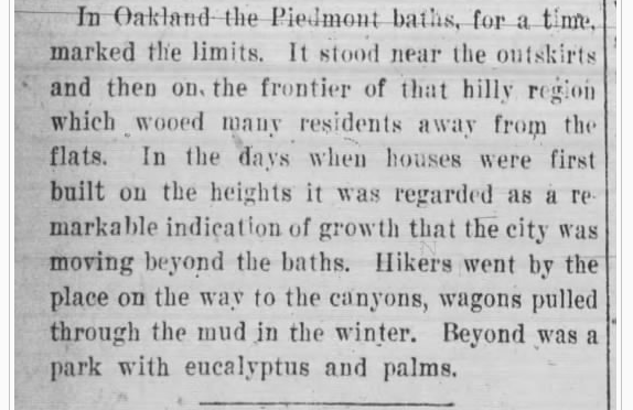
From a 1927 remembrance, Oakland Tribune

3. Subdivisions
In 1905 the Adams heirs agreed to subdivide Adams Point into what would become parkland by the lake and housing in the hills. House construction continued through the early 1910s, accompanied by the relocated St. Paul’s Episcopal Church on a plot near the lake.


St. Paul’s Episcopal School, completed next door in 1966, at first blush appears fashioned after the church. However the tower was almost an afterthought, when the architects were informed the building needed a fire stair. A 22-story residential tower joined the campus that same year.
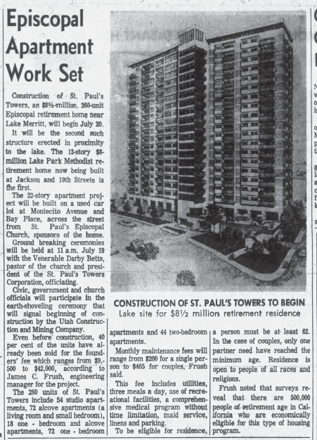
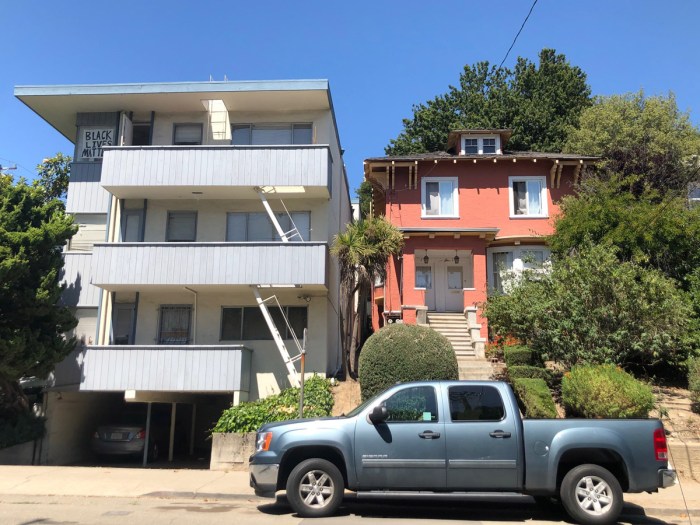
Not to suggest that apartment towers were exclusively a midcentury trend in Adams Point. On Lenox, two seven-story towers were completed in 1930 (by 1957, a soft story apartment building would nestle between them). Time and again, dense residences have been built alongside the 1900s bungalows.
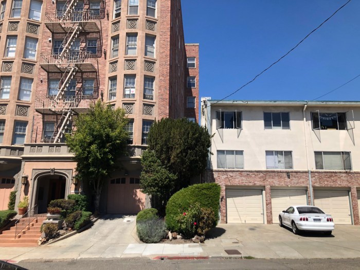

1910s bungalows and a 1973 midrise

4. The Triangle:
Edson Plaza – Adams Park – Conservatory Park – Veterans Memorial
Across 25 years, this “cheap piece of unsightly land” at the head of Lake Merritt was transformed into productive (human) use, under many guises. Edson F. Adams had the land improved by the 1900s as a private park, and eventually sold it to the City. At some point, the northern half was privatized, and two great parkfront structures were built: the five-story YWCA Blue Triangle Club (2332 Harrison) and Park View Manor (123…Bay? Place?? Fun fact: Bay was among many tree-named streets that originally spanned what would become uptown Oakland).
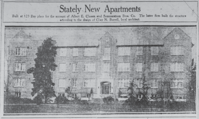
From 1925, the Park View Manor took “every advantage…of a unique setting afforded by a civic park fronting the apartment house,” according to the Tribune that February.

Certainly the Veteran’s Memorial Building afforded an even better view of the park – or what would remain of it – and the lake. It was completed in 1928. Being a memorial allowed the structure’s construction on City park land.


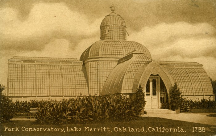
5. Conservatory
Today no sign remains of the ornate conservatory that once occupied the grounds of the Veterans Memorial Building.
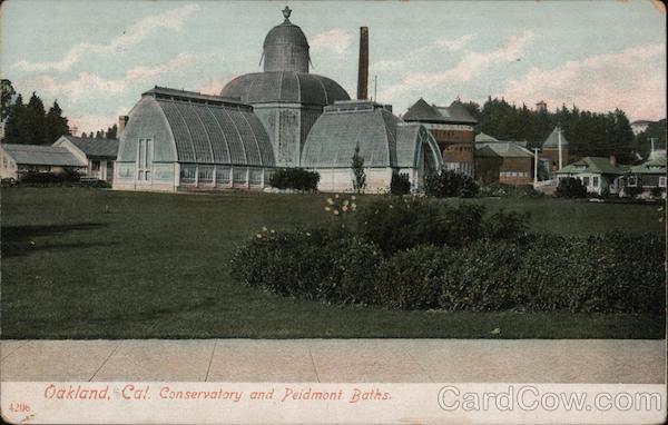
The conservatory was first built on the estate of Albion Kieth Paris Harmon where the Oakland Cathedral and probably a Kaiser tower now stand.

Harmon estate, looking west
In 1901, after AKP Harmon’s passing, Edson F. Adams acquired the conservatory and had it relocated (evidently in one piece) two blocks to the Edson Plaza. Within five years (and following some pipe fun), the conservatory and the park had become City property. In no time at all the conservatory was a beloved civic destination. It even housed vegetable starts in 1918 to support the war effort. Then, somewhat inexplicably later that same year the conservatory was dismantled.

6. Valdez
Harrison probably wasn’t a major street until freeway offramps funneled commuters and visitors to entertainment and offices in the mid-20th century. Today Harrison marks a clear boundary between Adams Point and the new developments near Broadway. “Valdez Triangle” – the blocks bound by Harrison, Grand, Broadway, and 27th Street (once Bay, once the course of Glen Echo (once Cemetery) Creek) – is having its own moment of stylistic meshing in the 21st century.
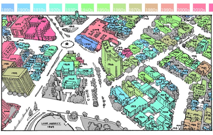
Postcard colored by year of completion. (With a guess taken on the 7-Eleven.)


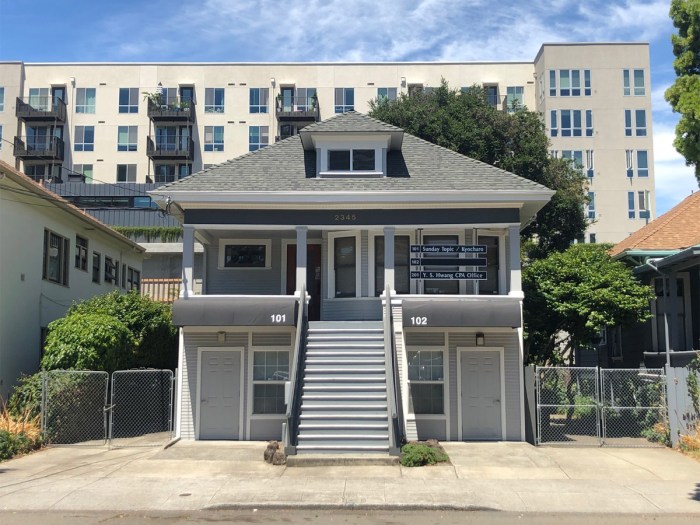
This unnamed corner apartment house on the southeast corner of 24th & Valdez dates back to 1910. When finished it afforded a view of Lake Merritt and the conservatory. Before that, in the 1890s apparently an 1,100-seat baseball stadium briefly occupied this land.

Houses on 24th Street from the 1890s – 21st century apartments down Valdez – a garage from the 30s still operates; it’s boarded up for the George Floyd protests

The 1930s store facing them
On Waverly, west of Harrison, a cluster of 1908-1910 bungalows are probably the most reminiscent of the Little House phenomenon. Author Virginia Lee Burton reminds us American urbanization and rapid change is nothing new. We might try to look forward as much as we look behind.


Pingback: Edson Plaza and Conservatory – A Bit of History
Pingback: Edson Plaza and Conservatory - A Bit of History
This is an amazing resource for local geography! Thanks for the details.